Federated View3D Buildings on Gis(Mapbox)
Overview
The Federated Model View (FMV) feature was introduced in Platform 5.1. This feature allows you view multiple instances of building models located at one geographical location, using GIS. The buildings are displayed at an outline or light level of model detail, at their correct geographical positions, without having to load all of the detailed information for each individual building's model.
You can click on any individual building to access its complete, detailed building model. You can also access the detailed building model by simply zooming in on a particular building and it will automatically switch to the detailed model view.
This approach allows you to inspect multiple buildings at one facility without adversely affecting the performance of the IafViewer in the browser. It is useful wherever several building models are grouped at a particular geographical location, such as different buildings located at an airport.
Figure: Federated Model view displaying three building models in same geographical region, displayed as outline 3D models
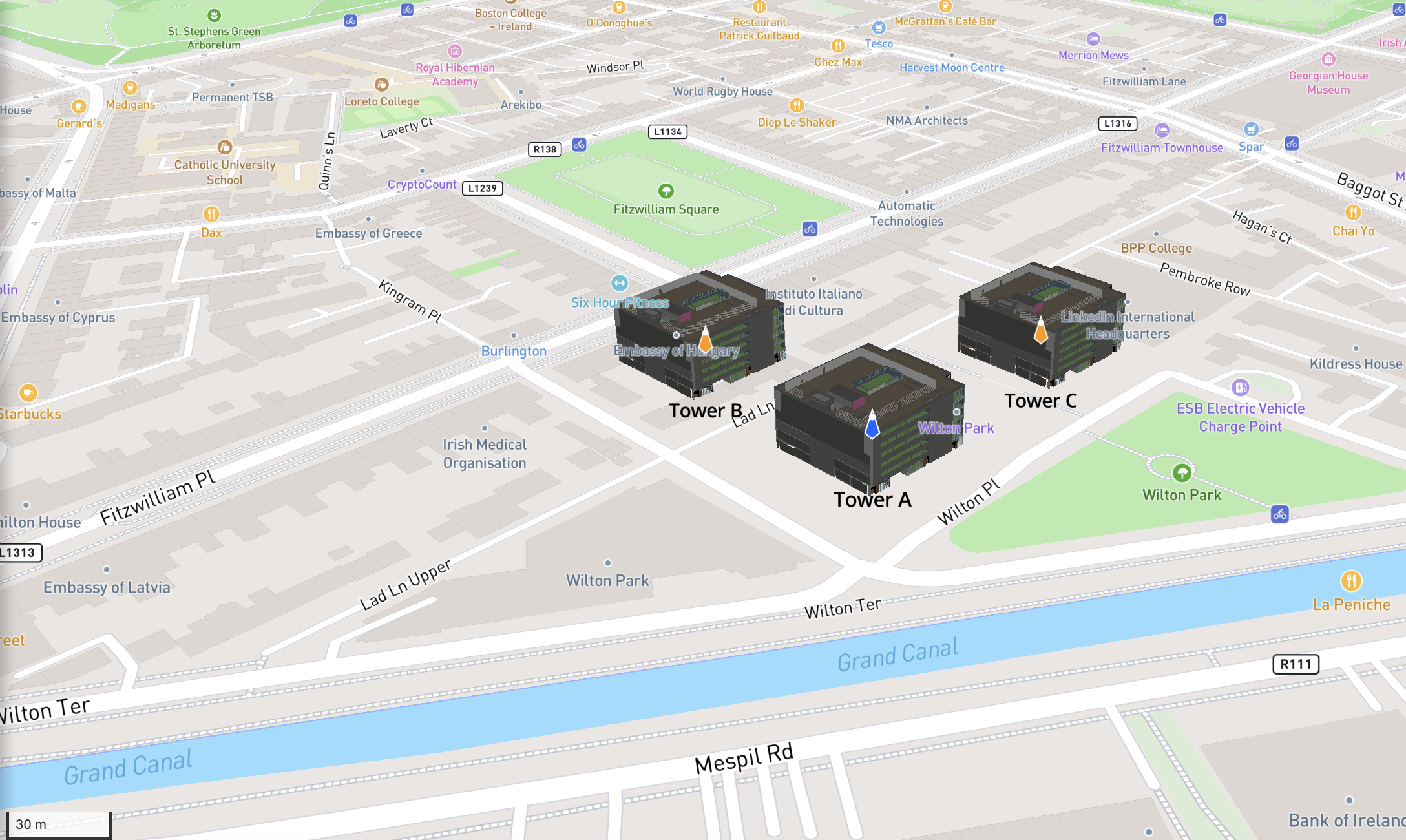
This page covers what the feature does for the end user, then how to configure {{IafViewerDBM}} for federated projects (multi-model workspaces). Other integration examples: Model Comparison Using View3D, UE with ArcGIS, Overview Map, and Photosphere, Multiple Selection with IafViewerDBM.
Reference model
To support the Federated Model view feature, the concept of a reference model has been introduced for each building.
A reference model offers two versions of a building model:
-
A light 3D outline of the building model for displaying in its geographical context with surrounding buildings in the Federated Model view.
-
A complete, detailed bimpk model for viewing individual buildings, which can be fully explored using the existing 2D and 3D viewing modes.
Navigating the Federated Model View
Enabling Federated Model View
To see the Federated Model View, do the following:
-
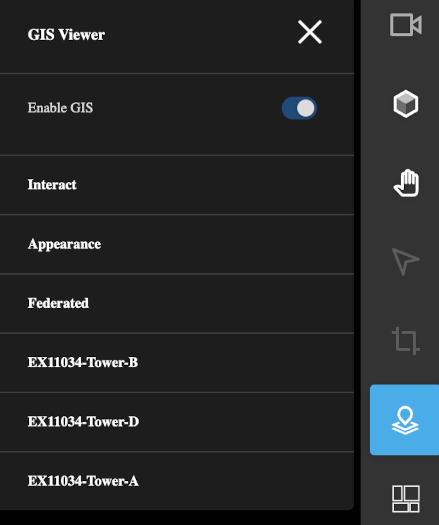
Click the GIS Viewer icon in the right menu side-bar. This will reveal the set of GIS Viewer menu.
-
Enable that the Enable GIS switch setting at the top of the menu is enabled.
-
Also ensure that under the Federated setting, that the Federated Mode is set to Dynamic.
Figure: The Enable GIS setting in GIS Viewer options must be turned on
Switching from Federated Model View to detailed view
To move from the Federated Model View showing several outline models, to a detailed single model view, do the following:
-
Navigate through the Federated Model View, using mouse and scroll wheel as desired.
-
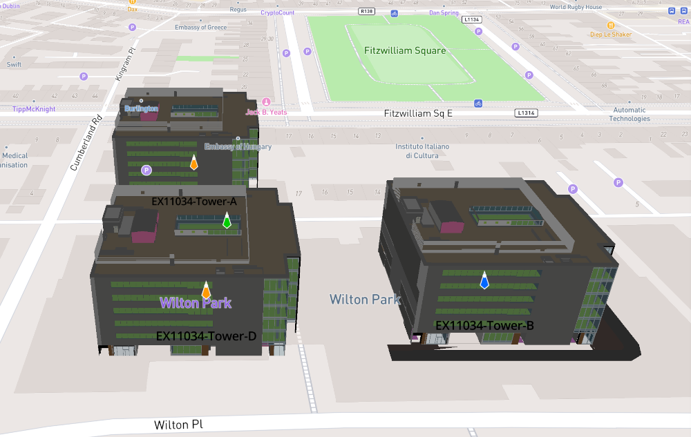
Keep zooming into the building model you are interested in. When you get close enough, the view will automatically switch from the Federated Model View to a detailed 3D model view of that individual building. Click on the building to explore its detailed model view.
Note: When navigating the Federated Model View, if you lose sight of a building model at any point, click the Home icon in the menu side-bar on the right to reset the view.
Figure: Federated Model View showing three outline building models in same geographical location
Building blocks
A workspace can contain multiple BIMPKs models, each typically representing one building. The viewer loads and displays these models based on {{modelComposition.defaultFederationType}}. When GIS is enabled, it also uses {{gis.federatedMode}} to control how multiple models appear on the map.
The core components are:
- View3D / View2D — IafViewer 2D-3D Features
- GIS — IafViewer GIS (Mapbox)
- modelComposition — Model composition
How those prop groups fit together is covered on the Enhanced Viewing Modes hub. This page focuses on consuming them for a federated multi-building GIS layout.
How to set up a Federated Model View
The main steps in setting up a federated view are:
Each step shows only the props it introduces. The complete example at the end of the page carries the whole configuration.
Step 1: Configure federation type
Set {{defaultFederationType}} to "Project" so the viewer loads every model in the workspace, and use {{initial}} to choose which disciplines start loaded and visible.
modelComposition: {
  defaultFederationType: "Project",
  initial: {
    Architectural: { load: true, visible: true }
    // remaining disciplines default to { load: false, visible: false }
  },
  quality: 'high'
}
{{quality}} here is set for eager dynamic loading; low is the default and the safer starting point — see IafViewer Performance Tips before raising it.
For the other federation types and what each one loads — including which props a single model needs — see Federation Type vs Federated Mode.
Step 2: Configure GIS and Federated Mode (for multiple models on map)
When showing multiple models on the map, enable GIS and set federated mode.
gis: {
  enable: true,
  token: "<your-mapbox-token>",
  federatedMode: EvmUtils.EvmFederatedMode.Outline,  // or Dynamic, Markers
  primaryModelId: "<reference-model-id>",            // optional
  showMapMarkers: true
}
{{onFederatedModeChanged}} and {{onReferenceModelChanged}} are available if your app needs to react to those changes; both appear in the complete example. For what each federated mode renders, see Federated Mode.
Step 3: Manage camera when GIS and View3D are both enabled
When GIS and View3D are both enabled, treat {{IafViewerDBM}} as the single place that drives camera / map position. Driving Mapbox or the 3D camera yourself from app code usually desyncs the two views.
  User interaction (pan, zoom, fly-to, marker click)
              │
              ▼
         IafViewerDBM
         (supported camera / map APIs)
           │         │
           ▼         ▼
        GIS map ◄──► View3D     ← stay in sync

  App code calling Mapbox or View3D camera directly  ──✗──► map and 3D diverge
| Guidance | |
|---|---|
| Do | Let the user interact with the viewer, or use documented viewer props and callbacks that update the session. |
| Do | Use GIS UI and federated controls (Reference Model, fly-to, markers) when both map and 3D are on. |
| Don’t | Call Mapbox camera methods (for example setCenter / flyTo on the raw map) from your app while View3D is enabled. |
| Don’t | Drive the View3D camera from app code independently of the map when both are enabled. |
Prefer observer callbacks such as {{view3d.onCameraUpdate}} if your app needs to mirror camera state elsewhere:
onCameraUpdate: {
  delayInMs: 300,
  callback: (camera) => { /* sync to external state if needed */ }
}
Step 4: Render Federated Viewer
<IafViewerDBM
  {...viewerProps}
  model={undefined}
  title="Federated Workspace"
/>
With Project federation type, omit {{model}} — or pass it to set the primary model — so all workspace models load.
Complete example
import React from 'react';
import IafViewerDBM from '@dtplatform/iaf-viewer';
import EvmUtils from '@dtplatform/iaf-viewer/src/common/evmUtils';

function FederatedProjectViewer({ workspaceId }) {
  const viewerProps = {
    serverUri: 'https://api.invicara.com/',
    modelComposition: {
      defaultFederationType: "Project",
      initial: {
        Architectural: { load: true, visible: true },
        Structural: { load: false, visible: false },
        Mechanical: { load: false, visible: false },
        Electrical: { load: false, visible: false },
        Plumbing: { load: false, visible: false },
        FireProtection: { load: false, visible: false },
        Infrastructural: { load: false, visible: false },
        default: { load: false, visible: false }
      },
      quality: 'high'
    },
    view3d: {
      enable: true,
      showToolbar: false,
      onCameraUpdate: {
        delayInMs: 300,
        callback: (camera) => { /* optional: sync to state */ }
      }
    },
    view2d: {
      enable: true
    },
    gis: {
      enable: true,
      token: process.env.MAPBOX_TOKEN,
      federatedMode: EvmUtils.EvmFederatedMode.Outline,
      primaryModelId: undefined,
      showMapMarkers: true,
      onFederatedModeChanged: (mode) => console.log('Federated mode:', mode),
      onReferenceModelChanged: (modelId) => console.log('Reference model:', modelId)
    },
    enablePersistence: false
  };
  return (
    <div style={{ width: '100%', height: '100%' }}>
      <IafViewerDBM
        {...viewerProps}
        model={undefined}
        title="Federated Workspace"
      />
    </div>
  );
}

export default FederatedProjectViewer;
Useful concepts
Federation Type vs Federated Mode
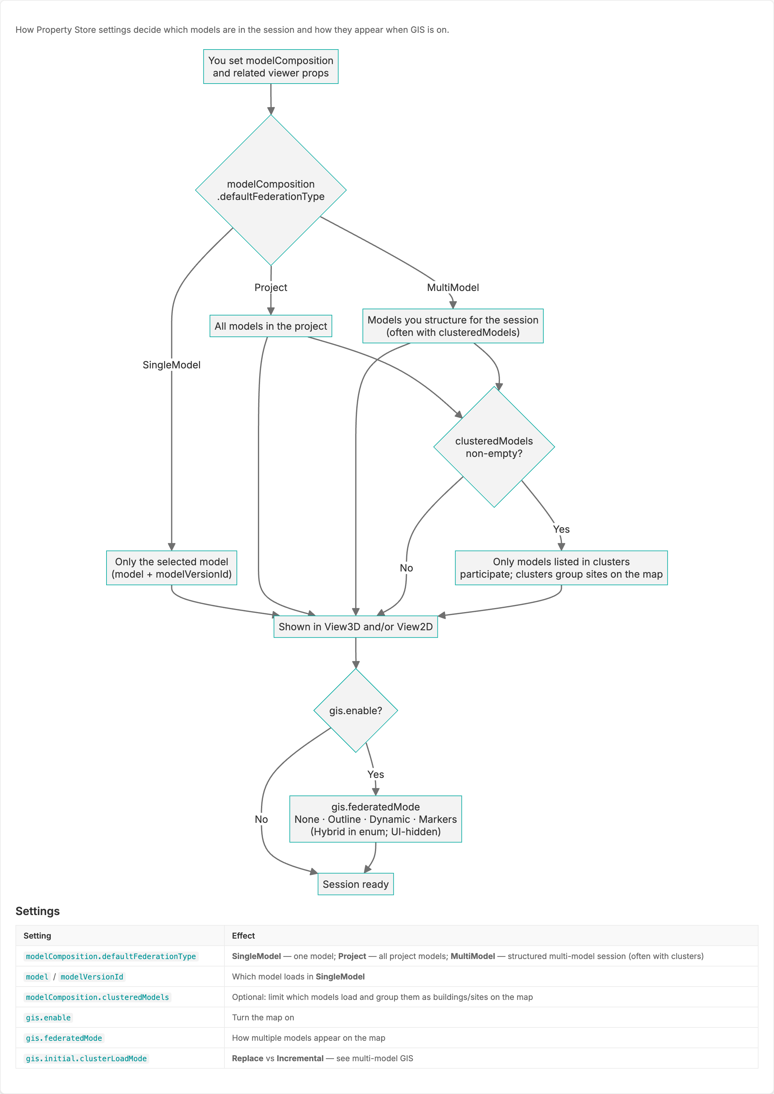
The Federation Type (modelComposition.defaultFederationType) controls which models are loaded.
Figure: Flow Diagram - Federation Types and Model Loading
| Value | Behavior |
|---|---|
SingleModel | Only one model, determined by {{model}} and {{modelVersionId}} (default) |
Project | All models in the current workspace or namespace |
MultiModel | Models listed in {{clusteredModels}} only. View3D outlines come only from View3D clusters (no all-project fallback). APS clusters are placed as GlbDraco outlines. |
How federation type feeds the views (and GIS, when enabled):
  modelComposition.defaultFederationType
           │
           ├── SingleModel ──► selected model (model + modelVersionId)
           │
           ├── Project ──────► all workspace models ──┐
           │                                          │
           └── MultiModel ───► clustered models only ─┤
                                                      │
                                                      ▼
                                         clusteredModels
                                         non-empty?
                                           │
                          No ──────────────┤──────── Yes
                           │               │          │
                           ▼               │          ▼
                    all session models     │   only models listed
                           │               │   in any cluster;
                           └───────┬───────┘   clusters = map sites
                                   ▼
                          View3D and/or View2D
                                   │
                     gis.enable? ──┤
                          No ──────┴──► session ready
                          Yes ─────────► continues under Multi-model GIS
When GIS is on, Multi-model GIS picks the flow up from here and follows the models onto the map.
Optional {{modelComposition.clusteredModels}} (when federation type is Project or MultiModel): if non-empty, only model IDs listed in clusters participate, and each cluster groups models that share one map site / outline.
View3D and APS clusters
Each {{clusteredModels}} entry can set an optional evmMode. Omit it for a View3D cluster, or set it to 'aps' for an APS cluster. ids is the canonical key for the cluster's models. modelIds is still accepted as a legacy alias for View3D clusters only.
clusteredModels: [
  // View3D (default): ids are model _ids, outline from Graphics Service ViewOutline
  { ids: ['id1', 'id2'], id: 'gp', name: 'Garden Pavilion', center: { lng: 77.719, lat: 13.199 }, zoom: 17 },
  // APS: ids are design URNs, outline from APS Extra Derivatives (GlbDraco)
  { evmMode: 'aps', ids: ['urn:adsk.objects:os.object:bucket/model.rvt'], title: 'APS Building',
    center: { lng: -6.25, lat: 53.33 }, altitude: 0, bearing: 0, zoom: 18 },
]
The federation type decides how the viewer treats each kind of cluster:
| Federation type | View3D clusters | APS clusters |
|---|---|---|
SingleModel | Unchanged | Ignored |
Project | Unchanged (all project models; clusters act as a filter) | Not seeded or placed |
MultiModel | Outlines only from View3D clusters (no all-project fallback) | Placed as GlbDraco outlines |
For how APS clusters appear on the map, see APS models on Mapbox.
Federated Mode (gis.federatedMode)
The Federated Mode (gis.federatedMode) controls how multiple models are displayed on the GIS map (when GIS is enabled).
| Value | Behavior |
|---|---|
None | Single model mode |
Outline | Models rendered as GLTF outline layers |
Dynamic | Full / detailed models on the map (distance- and zoom-based switching with outlines) |
Markers | Location markers only, no 3D models |
Note:
{{primaryModelId}}sets the reference model.{{onFederatedModeChanged}}and{{onReferenceModelChanged}}are available callbacks.Outlineis the default.Hybridexists onEvmUtils.EvmFederatedModebut is not offered in the GIS UI today. There is noSoftfederated mode — useOutline.
Multi-model GIS
For campus-scale maps, combine federation type with GIS settings. This picks up where Federation Type vs Federated Mode leaves off — the models are already chosen; what follows is how they reach the map.
Figure: Flow Diagram - Federated Models and GIS and Property Store
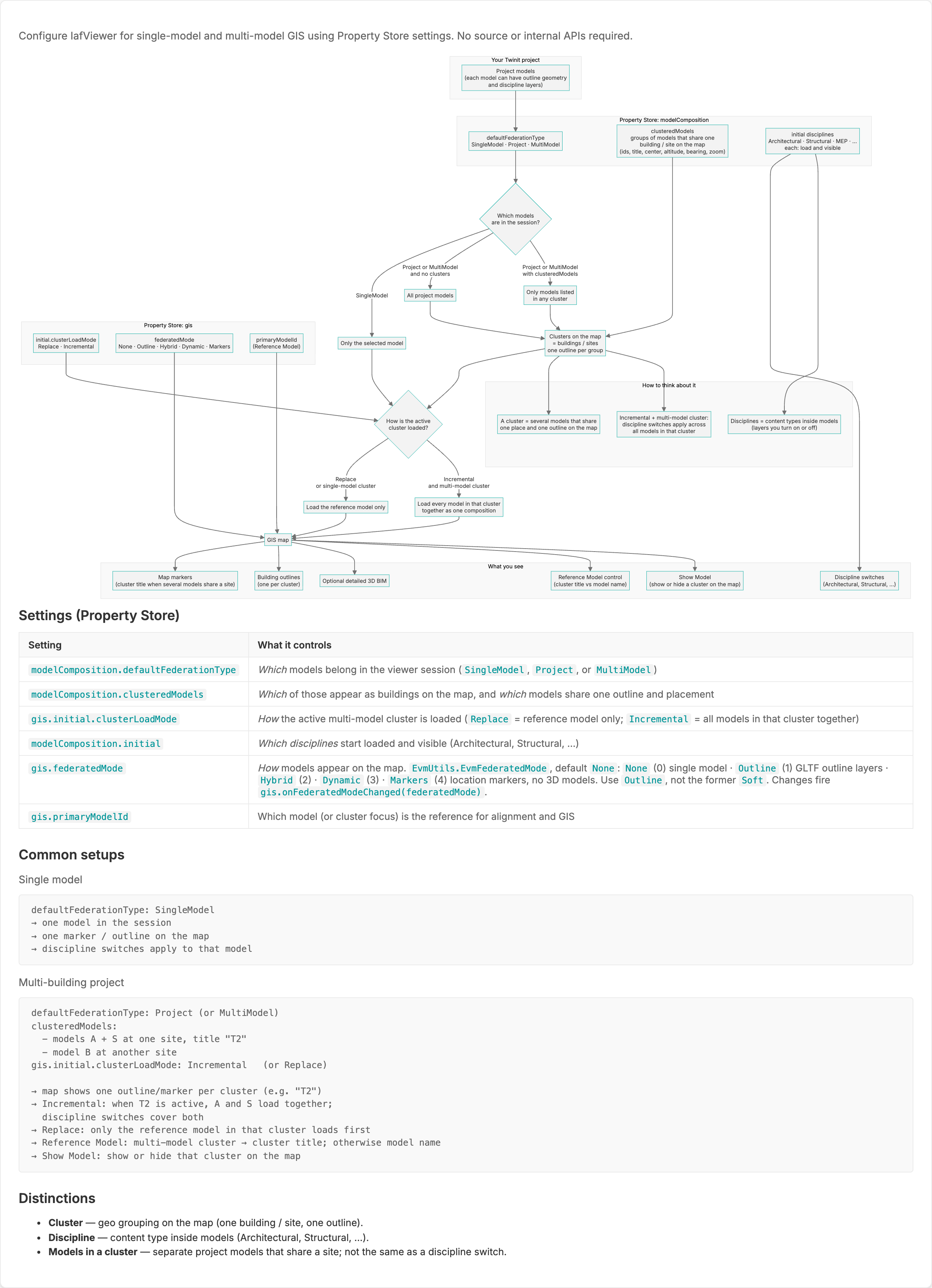
Concept flow (props only — no package internals):
  Models selected by federation type (+ optional clusteredModels)
                             │
                             ▼
                   Clusters on the map
                   (one building / site, one outline per group)
                             │
                             ▼
              gis.initial.clusterLoadMode
                             │
              ┌──────────────┴──────────────┐
              ▼                             ▼
           Replace                     Incremental
     reference model only        all models in that cluster
     in the active cluster       load together as one composition
              │                             │
              └──────────────┬──────────────┘
                             ▼
                      GIS map (+ optional View3D)
                             │
         ┌───────────────────┼───────────────────┐
         ▼                   ▼                   ▼
   map markers         building outlines    detailed 3D BIM
   (cluster title)     (one per cluster)    (when View3D on)
         │
         ├── gis.federatedMode (None · Markers · Outline · Dynamic)
         ├── gis.primaryModelId (Reference Model)
         └── modelComposition.initial (discipline load / visible)
| Setting | What it controls |
|---|---|
modelComposition.defaultFederationType | Which models belong in the session |
modelComposition.clusteredModels | Which of those appear as buildings on the map, and which models share one outline / placement |
gis.initial.clusterLoadMode | How the active multi-model cluster loads: Replace (reference model only) or Incremental (all models in that cluster together) |
modelComposition.initial | Which disciplines start loaded and visible |
gis.federatedMode | How models appear on the map (markers, outline, dynamic, …) |
gis.primaryModelId | Reference model for alignment and GIS |
Distinctions
- Cluster — geo grouping on the map (one building / site, one outline).
- Discipline — content type inside models (Architectural, Structural, …).
- Models in a cluster — separate project models that share a site; not the same as a discipline switch.
- Incremental + multi-model cluster — discipline switches apply across all models in that active cluster.
Typical setups
Single model
  defaultFederationType: SingleModel
  → one model in the session
  → one marker / outline on the map
  → discipline switches apply to that model

Multi-building project
  defaultFederationType: Project
  clusteredModels:
    - models A + S at one site, title "T2"
    - model B at another site
  gis.initial.clusterLoadMode: Incremental   (or Replace)

  → map shows one outline / marker per cluster (e.g. "T2")
  → Incremental: when T2 is active, A and S load together;
    discipline switches cover both
  → Replace: only the reference model in that cluster loads first
  → Reference Model: multi-model cluster → cluster title; otherwise model name
  → Show Model: show or hide that cluster on the map
Related
- Model Comparison Using View3D — multi-instance View3D comparison
- UE with ArcGIS, Overview Map, and Photosphere — full EVM stack navigation
- Multiple Selection with IafViewerDBM — app-owned single vs multi selection
- How prop groups fit together — modelComposition / view3d / view2d / gis structure
- IafViewer 2D-3D Features — View3D and View2D props
- IafViewer GIS (Mapbox) — Mapbox GIS UI controls and GIS props
- IafViewer APS — APS designs in clusters (
evmMode: 'aps') and on the map - Model composition — modelComposition props and PropertyStore resolution
- IafViewer Performance Tips — composition, federation type, quality, multi-mode cost
- IafViewer FAQs — consumer FAQs (GIS, composition, migration)
- IafViewer Overview
- IafViewer — mode object prop tables
- IafViewerDBM